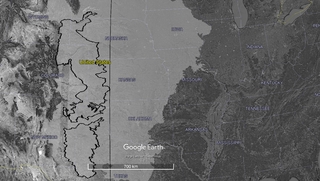
The western US is generally much drier than the eastern half of the country. The drivers of these patterns are complex, but to simplify, the eastern US has access to oceanic moisture from the Gulf of Mexico, the Atlantic Ocean, and the Great Lakes. In contrast, in the western US, north-south mountain ranges (e.g., the Cascades and Sierra Nevada) intercept moisture-laden westerly winds from the Pacific, creating a narrow zone of orographic precipitation along the coast and a dry rain shadow across most of the West.
The transition zone between the wet forests of the East and the deserts of the West consists of the semi-arid grasslands of the Great Plains (Figure 1), once known to American explorers as the Great American Desert—desert not in the modern sense, but rather in the sense of forbidding, uninhabited land. (Those explorers failed to see that indigenous peoples had been thriving in the Plains for many generations.) John Wesley Powell—one-armed Civil War veteran, geology professor, leader of the famed 1869 expedition on the Colorado River, and second director of the USGS—wrote about this transition zone in his Report on the Lands of the Arid Region of the United States, submitted to Congress in 1879. Powell defined the eastern boundary of the “Arid Region” as the line where annual rainfall falls below 20 inches, the minimum he thought necessary for rain-dependent agriculture. He identified the 20 inch isohyet (line of equal rainfall) as corresponding roughly to the 100th meridian of latitude, or about halfway across the Great Plains. He also cautioned that even the wetter eastern portion of the Great Plains—what he called the Sub-humid Region, extending east to the 28 inch isohyet—“will be subject more or less to disastrous droughts, the frequency of which will diminish from west to east.” In these transitional lands, Powell realized, natural climate variability could well be the difference between a bumper crop and a failed one.
