Groundwater Flow: A Closer Look
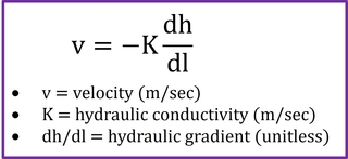
The rate and direction of groundwater flow are notoriously complex and hard to understand. But the basic drivers are captured by this simple equation, known as Darcy’s Law.
In English, this equation is telling us that groundwater moves downslope (hence the negative sign) at a rate that is proportional to two parameters:
- The hydraulic gradient (dh/dl) is essentially the slope of the water table (though we will add a caveat later in this section). Just like surface water, groundwater moves downhill in response to gravity; the steeper the slope the faster it moves.
- The hydraulic conductivity (K) describes how easy it is for water to move through a particular sub-surface formation. The hydraulic conductivity is closely related to the permeability, which describes how easy it is for fluids in general (not just water) to move through the formation.
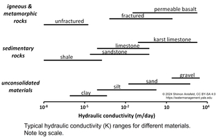
A formation’s hydraulic conductivity is largely determined by the grain size of the particles that make it up. Larger-grained formations (e.g., sand and gravel) don’t hold onto water very tightly, so these formations have high hydraulic conductivities, while silt and clay have much lower hydraulic conductivities, since water is held tightly in the small pores. In other words, in response to a given hydraulic gradient (e.g., that created by pumping water from a well), water will move much more quickly through sand than through clay.
The hydraulic conductivity thus allows us to distinguish between aquifers: high-K formations that will produce large amounts of water when pumped; and aquitards (also referred to as confining layers): low-K formations that don’t allow much water movement and therefore can’t be used as a water source.
In addition to sand-and-gravel aquifers, aquifers can also form in bedrock, with water moving through inter-connected fractures or cavities in the rock. Bedrock aquifers can be found in formations with relatively high hydraulic conductivity: highly-fractured igneous and metamorphic rocks; clastic sedimentary rocks with relatively large grains (e.g., sandstone); and chemical sedimentary rocks that can dissolve in water (most notably limestone and other carbonate rocks). In contrast, unfractured igneous and metamorphic rocks, and fine-grained sedimentary rocks (e.g., shale) have much lower hydraulic conductivity and do not generally form aquifers. Bedrock aquifers tend to behave less predictably than unconsolidated aquifers, since their hydraulic conductivity is very variable at small spatial scales; water moves quickly through (irregularly-spaced) fractures and very slowly through the rest of the rock.
One particularly important type of bedrock aquifer is found in karst formations, where limestone (or other soluble rocks) has been dissolved by water over time. Because of these dissolution processes, karst landscapes often have unique features such as underground rivers, large caverns, and sinkholes where the surface has collapsed into the cavities underneath it. Karstic regions tend to lack large rivers, since surface water readily percolates into the subsurface through sinkholes and other dissolution features that allow for rapid localized groundwater recharge. Groundwater in karst aquifers can move quite quickly, and these aquifers are often very productive (i.e., they produce high flows when pumped), but will respond more quickly to drought than a typical aquifer.
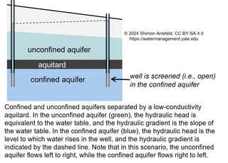
The aquifer that we looked at in our discussion of the hydrologic cycle is an example of an unconfined aquifer—an aquifer that lies immediately under the vadose zone. In contrast, confined aquifers are overlain by a low-permeability confining layer, which prevents water flow through it. The water in a confined aquifer is often under high pressure, meaning that a well screened in the confined aquifer will have a water level that is higher than the top of that aquifer, as shown in the image to the left. If the pressure is high enough, the equivalent water level (the hydraulic head) will be higher than the ground surface, and a well tapping this artesian aquifer will flow on its own without pumping. For a confined aquifer, the hydraulic gradient in Darcy’s Law is not the slope of the water table, but the slope of the hydraulic head.
Reality is usually more complicated than suggested in this image, with the same aquifer sometimes having different sections that are confined, unconfined, and partly confined (i.e., overlain by a formation of intermediate hydraulic conductivity). Many confined aquifers have a recharge zone—an unconfined section where water enters from the surface—as well as a discharge zone, where water flows to the surface. Still, as a generalization, the water in confined aquifers is often older, slower-moving, and less connected to the surface (thus more protected from pollution) than in unconfined aquifers.
Aquifers (both confined and unconfined) can also be classified into recharging vs. fossil aquifers. As the name implies, recharging aquifers are regularly recharged by precipitation and percolation, while fossil aquifers have negligible recharge rates. Many fossil aquifers formed under climatic conditions that were different from the present. For example, the mammoth Nubian Sandstone Aquifer in North Africa was formed from recharge during the early Holocene, when the Sahara was much wetter than today.
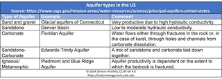
As shown in the table to the left, the USGS identifies five general types of aquifers in the US, including both confined and unconfined aquifers with matrices ranging from unconsolidated materials to crystalline rocks. Some aquifers are comprised of large, relatively homogenous areas, others are much smaller and patchier, and still others are made up of a complex network of partly-interconnected sub-aquifers.