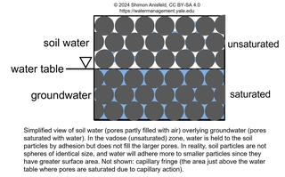
Water stocks are stores of water, expressed in units of volume (or sometimes mass). Most of these stocks will be quite familiar to readers and are described very briefly, but we spend more time on soil water and groundwater, which are generally less familiar. For data on the volume of water in various global stocks, see Chapter 2 Table 1 of the book.

Oceans: The five oceans (Pacific, Atlantic, Indian, Arctic, Southern) cover 70% of our planet and hold more than 95% of the earth’s water, which is, of course, salt water.

Freshwater lakes: A handful of large lakes—Baikal in Asia, Tanganyika and Malawi in Africa, and the Great Lakes in North America—make up about 70% of global lake freshwater volume, but there are estimated to be over 1.4 million total natural lakes (Messager et al. 2016; this estimate does not include lakes <10 ha in area), and many thousands of human-made reservoirs.

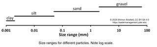
Salt lakes: Salt lakes are saline water bodies that are not connected to the ocean. The Caspian Sea is by far the world’s largest salt lake, but there are many other notable examples, including the Great Salt Lake in Utah, Mono Lake in California, the Dead Sea in the Middle East, and the Aral Sea in central Asia. All of these are terminal lakes, meaning that they have no outlet; water, carrying dissolved salts from rock weathering, flows in from rivers and then evaporates, leaving its salt load in the lake.

Glaciers and ice sheets: Glaciers are large masses of ice formed over time from compression of snowfall over cold land masses, generally high mountains or polar regions. The glaciers in Greenland and Antarctica cover huge areas and are referred to as continental glaciers or ice sheets

Atmospheric water: Water is found in the atmosphere in two forms: gas (water vapor) and aerosols (suspended droplets of liquid water or particles of ice and snow). 

schematic of soil water

Soil water and groundwater: Soils are composed of two components: solid particles (containing both organic and inorganic material) and the pores between them, which can be filled with either air or water (see figure). The fraction of a soil’s volume that is made up of pores is called the soil’s porosity, and is typically somewhere between 25% (for highly compacted soils) and 60% (for highly porous, organic-rich soils). The fraction of the pore space that is filled with water (as opposed to air) can range from near zero (for very dry soils) to 100% (for saturated soils), and can change rapidly in response to rain events. The amount of water in soils can also be described by the volumetric water content (VWC): the fraction of the total soil volume that consists of water. 

Soils near the surface are often unsaturated (the pores are partly filled with air), but deeper layers are often saturated with water, which is referred to as groundwater. The soil water zone, also referred to as the vadose zone, can be thought of as a thin layer overlying the deeper groundwater zone—though in some cases the vadose zone can be many tens of meters thick, so can extend well below the soil into the underlying sediment or rock. The transition point between soil water and groundwater—that is, the uppermost boundary of the saturated zone—is referred to as the water table,* and is indicated with an upside-down triangle. Groundwater is a liquid that can be potentially pumped out and used by people, but soil water is not; instead, it is tightly held by adhesion to the soil particles, though some of it can be tapped by plants to meet their transpiration needs. Soil water is referred to as green water, in contrast to the blue (liquid) water of groundwater or surface water. 

* Technically, the water table is the location where water pressure is zero (relative to atmospheric pressure), while below the water table the water pressure is positive and above the water table the water pressure is negative. The capillary fringe is a thin zone above the water table, where water is drawn upwards by capillary forces, resulting in saturated pores despite a negative water pressure.

graph of particle sizes

The behavior of water in soils is strongly affected by the texture of the soil: the mix of different particle sizes that make it up. Soils dominated by small clay particles have a high surface area, so water is held tightly in the numerous small pores and is not easily tapped by plants, while sandy soils, with their large pores and low surface area, let water flow through them very easily. Loam soils—with a mixture of sand, silt, and clay—hold onto water tightly but not too tightly, so they have the highest ability to store water for use by plants (the available water capacity), so tend to be the most productive. High soil organic matter content increases the available water capacity by increasing the porosity of the soil, while soil compaction (often caused by the use of heavy machinery in wet conditions) creates dense soils with low available water capacity.

Wetlands: Wetlands are locations where soils are frequently inundated (water above the surface) or saturated (pores are filled with water). Wetlands can be categorized by their vegetation (e.g., swamps are wooded, marshes are dominated by grasses) or by their water source (e.g., bogs receive water inputs almost exclusively from precipitation, fens are groundwater-dominated, and tidal wetlands are regularly inundated by the tides). The presence of water in wetland soils often leads to depletion of O2, slow decomposition, and the accumulation of thick organic deposits known as peats.